Solution
Flood Warning System
Early flood warning infrastructure that detects rising water in real time and alerts at-risk communities before evacuation routes are cut off.
What Is a Flood Warning System?
A Flood Warning System is the integrated infrastructure that detects rising water in real time and converts that data into a population-wide alert before the flood actually arrives. It is the only category of public-safety system designed to compress the gap between a sensor crossing a threshold and a person at risk hearing a siren — a gap that, in flash floods, is measured in minutes.
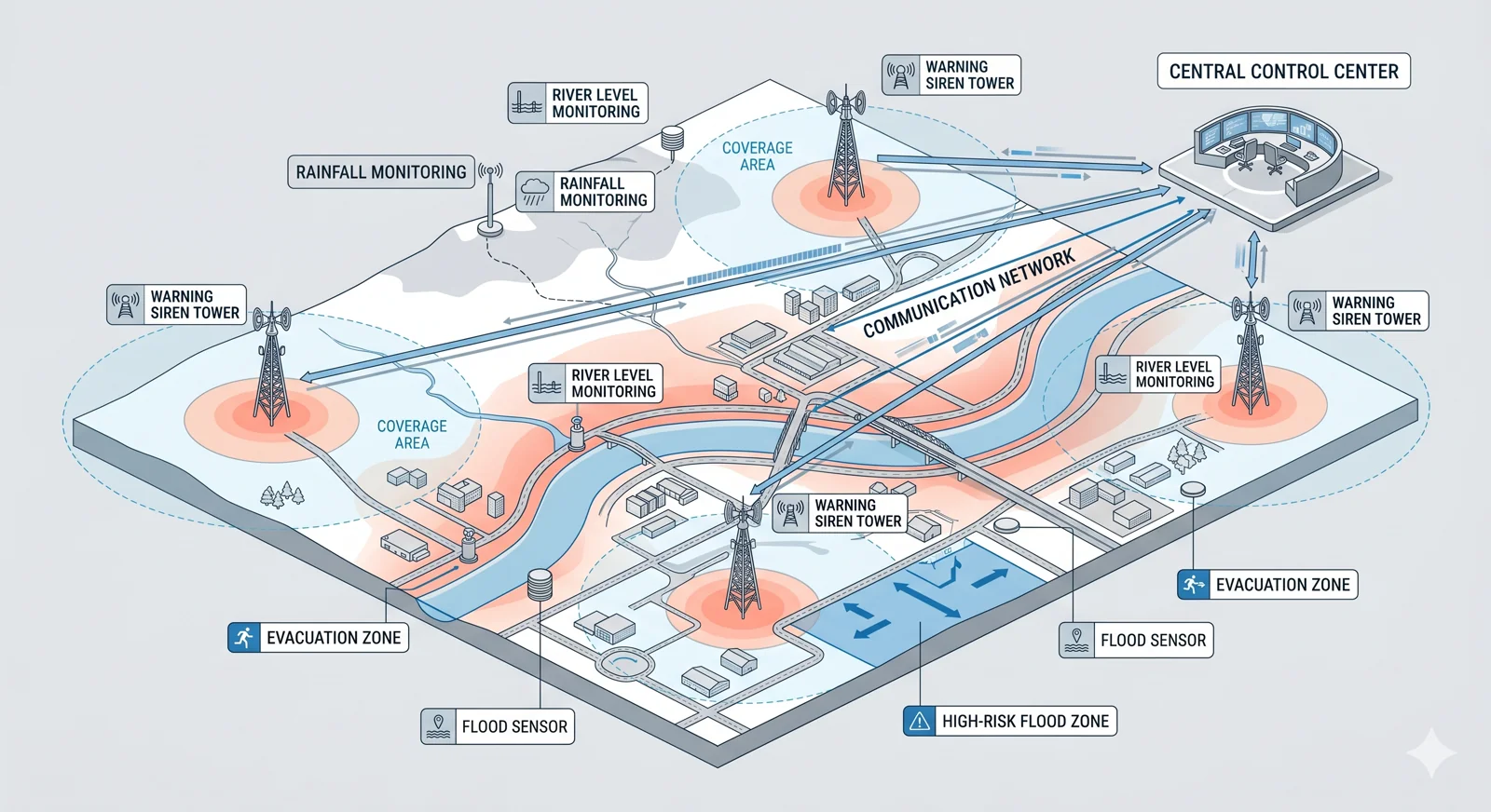
Architecturally, a flood warning system has four layers. The sensing layer combines river-level gauges, rainfall sensors, radar precipitation tracking, and dam-discharge monitors. The communication layer carries that data over redundant radio, cellular, and IP links to a central control unit. The decision layer applies pre-configured thresholds and predictive models to determine when, where, and at what intensity to alert. The last-mile layer — high-output electronic sirens, voice-broadcast loudspeakers, and mobile WEA — physically reaches the people in the flood path.
What separates flood warning from generic weather alerting is the last mile. A flood prediction in a meteorological model means nothing if it does not reach the elderly resident asleep at 03:00 in a riverside cottage, the family camping by a riverbank, or the workers at a low-lying construction site. Mobile alerts miss anyone outdoors, asleep, or without a charged device. Outdoor sirens are the only channel that physically wakes a sleeping town and audibly reaches a kilometer-wide area, regardless of whether a phone is on hand.
A flood warning system is also engineered for the conditions floods create. Sirens run on solar panels because grid power often fails first; cabinets are sealed to IP66 because flood water and driven rain are routine; communication has redundant paths because cellular towers can be among the first casualties of severe weather. The system must be at its strongest precisely when the surrounding infrastructure is at its weakest.
Why You Cannot Operate Without One
Flash Floods Give You Minutes, Not Hours
A flash flood can cut off evacuation routes 5 to 30 minutes after the rainfall peak. There is no time to call individual residents, post on social media, or wait for someone to forward a forecast. Only an automated chain — sensor → control center → siren — operates fast enough to matter.
Forecasts Without Last-Mile Delivery Save Nobody
Meteorological forecasts have improved dramatically. The 2021 Ahr Valley flood in Germany was forecast 24 hours in advance — and 134 people still died because the warning never reached them through any channel they would actually hear. A forecast is not an alert.
Sirens Reach People Who Phones Cannot
Mobile alerts assume an awake person with a charged, in-network device. Real flood victims are often asleep, outdoors, or in spotty coverage — exactly the people sirens reach. Audible warning at 110+ dB is the only channel that wakes a town.
Power and Cellular Networks Fail First
Grid power, cellular towers, and internet links are routine early casualties of major storms. Solar-powered sirens with dedicated radio backbones keep operating when public networks go dark — exactly when the population most needs to hear them.
Dam and Levee Failures Are Catastrophic and Predictable
When a dam, levee, or retention basin fails, hydraulic models can predict the inundation footprint and time-to-arrival within minutes. A flood warning system tied to dam-discharge monitors converts those minutes into evacuated communities.
Flooding Is Hyper-Local and Cross-Jurisdictional
Floods do not respect city or county borders. A river basin spans dozens of municipalities; a coastal storm surge crosses regions. Coordinated, hierarchical activation across jurisdictions — with regional override of local policy and override-from-above when needed — is essential.
How EnergoLab Solves It
EnergoLab delivers integrated flood warning systems that combine hydrological sensors, a decision-making control center, and a network of high-output electronic sirens with voice broadcast. When a river gauge crosses a predefined threshold, the system automatically triggers the appropriate alert scenario for the exposed area — sirens sound, evacuation instructions are broadcast over loudspeakers, and authorities are notified in parallel. Every part of the chain is engineered to operate without grid power and to remain functional in the harsh conditions floods create.
Real-World Impact
Natural Disaster (No System in Place)
Texas Hill Country Flash Flood — July 4, 2025
The Guadalupe River rose more than 7 meters in under an hour during pre-dawn hours of July 4, 2025, sweeping through Camp Mystic and other riverside communities in Kerr County, Texas. Over 100 people died, including dozens of children. There was no outdoor siren network in place — local officials had been advised for years to install one and had not. National coverage in the immediate aftermath posed the question directly: would flood sirens have saved lives in Texas?
Forecast Existed, Last-Mile Failed
Ahr Valley Flood — Germany, July 14–15, 2021
The German Weather Service issued a severe flood warning more than 24 hours before the Ahr River broke its banks. The forecast was correct. The population never heard it. Germany lacked a universal outdoor siren network and had no nationwide cell-broadcast — by the time mobile push notifications and word-of-mouth reached riverside villages, the water was already there. 134 people died in the Ahr Valley alone. The disaster prompted Germany to commit billions of euros to MoWaS cell-broadcast and outdoor-siren modernization.
Continuous Operation (Positive Case)
Mile High Flood District — Colorado, 1979–present
The Mile High Flood District protects a seven-county metro area around Denver and Boulder, operating early flood threat recognition in partnership with the National Weather Service for over four decades. The integrated system of stream gauges, rainfall sensors, predictive modeling, and outdoor warning has consistently provided enough lead time to evacuate threatened areas — a long-running demonstration that a properly maintained flood warning infrastructure measurably reduces casualties and property damage.
Key Capabilities
Automatic Threshold Activation
Configurable rules turn sensor data into alerts without manual intervention, with operator override at any stage.
Voice + Tone Broadcast
High-output sirens deliver both standardized warning tones and clear voice instructions for evacuation.
Solar-Powered Operation
Sirens stay online during grid failures — critical when flooding takes out local power infrastructure.
IP66 Outdoor Rating
Cabinets and acoustic units are sealed against driven rain, dust, and submersion of cabling.
Rapid Mobile Deployment
Portable units extend coverage to temporary risk zones — construction sites, road closures, evacuation routes.
Integration With Hydro Sensors
Open interface accepts water-level, rainfall, and dam-discharge data from third-party hydrological networks.
Products Used in This Solution
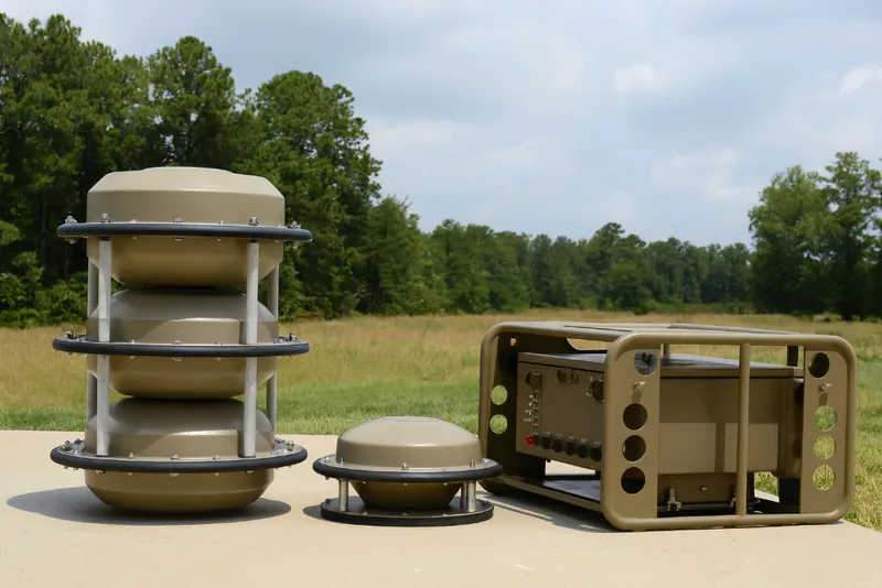
Mobile Alert System
A portable, robust alert system for rapid deployment in any environment. Ensures critical communication when it's needed most.
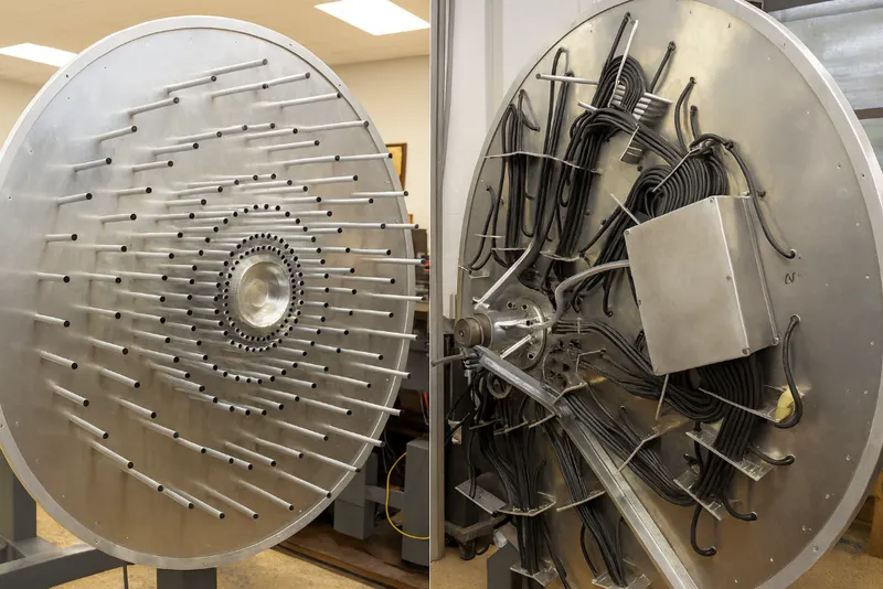
Acoustic Detector
Advanced acoustic radar system for detecting and tracking aerial and ground targets through sound wave analysis.
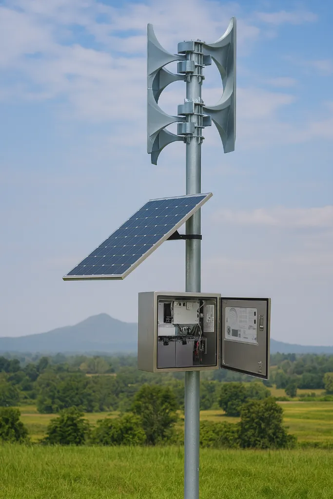
Electronic Siren with Cabinet
A powerful, solar-powered electronic siren complete with a weatherproof cabinet for long-range emergency alerts.
Typical Use Cases
- River-basin authorities protecting downstream communities
- Dam operators required to alert residents in the inundation zone
- Coastal municipalities exposed to storm surges
- Mountain regions vulnerable to flash floods and debris flows
Ready to Discuss Your Requirements?
Talk to our engineering team about your specific deployment scenario.